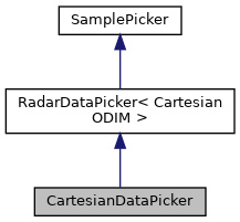
|
|
GeoFrame | frame |
| | Frame for converting coordinates.
|
| |
| int | current_i = 0 |
| | Optional utility. Called prior to writing the actual data to output stream.
|
| |
|
int | current_j = 0 |
| | Vertical coordinate.
|
| |
|
int | current_j2 = 0 |
| | Vertical inversed coordinate.
|
| |
|
int | width = 0 |
| |
|
int | height = 0 |
| |
|
FlexVariableMap | infoMap |
| | Information to be should in output file header.
|
| |
| ReferenceMap2 & | variableMap |
| |
|
|
typedef SrcType< CartesianODIM const > | src_t |
| | Input source type.
|
| |
|
typedef PlainData< src_t > | data_t |
| | Input data type.
|
| |
|
typedef DataSet< src_t > | dataset_t |
| | Input dataSet type.
|
| |
|
typedef std::map< std::string, const data_t & > | map_t |
| | Map type compatible with Sampler.
|
| |
|
double | x |
| | Metric coordinate corresponding to longitudinal coordinate.
|
| |
|
double | y |
| | Metric coordinate corresponding to latitudinal coordinate.
|
| |
|
double | lon |
| | Longitudinal coordinate (degrees)
|
| |
|
double | lat |
| | Latitudinal coordinate (degrees)
|
| |
|
const CartesianODIM & | odim |
| | Metadata for navigating and scaling grid data.
|
| |
◆ setPosition()
| void setPosition |
( |
int |
i, |
|
|
int |
j |
|
) |
| const |
|
virtual |
Sets image position (in 2D Cartesian space) and calculates corresponding geographical coordinates.
Reimplemented from SamplePicker.
The documentation for this class was generated from the following files:


 Public Member Functions inherited from RadarDataPicker< CartesianODIM >
 Public Member Functions inherited from SamplePicker
 Public Attributes inherited from SamplePicker
 Public Types inherited from RadarDataPicker< CartesianODIM >
 Protected Attributes inherited from RadarDataPicker< CartesianODIM >
 1.9.8
1.9.8